- NLW MS 23949E.
- File
- [1944x1951] /
Part of Dylan Thomas Trust manuscripts
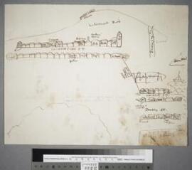
A two-page schematic sketch map of Llareggub, [1944x1951], drawn in brown ink by Dylan Thomas during the process of composition of his play for voices, Under Milk Wood.
The general topography of the town largely corresponds to the finished play; the map shows features such as Llareggub Hill and Donkey Down, with the homes of various characters and other buildings being identified along Coronation Street, Cockle Street and Donkey Street. On the reverse is an earlier abortive attempt, identifying only Ogmore-Pritchard, Willy Nilly and the Town Hall. The obverse of the map is reproduced in Douglas Cleverdon, The Growth of Milk Wood (London, 1969), pp. 12-13; Dylan Thomas, Under Milk Wood: The definitive edition, ed. by Walford Davies and Ralph Maud (London, 1995), p. 64; and Dylan Thomas, Under Milk Wood: A play for voices, ed. by Walford Davies (London, 2000), p. 64.
Thomas, Dylan, 1914-1953