- Peniarth MS 526 [RESTRICTED ACCESS].
- File
- 1583.
Part of Peniarth Manuscripts Collection
Calendarivm Gregorianvm perpetvvm, Antwerp : MDLXXXIII, with manuscript notes.
2 results with digital objects Show results with digital objects
Part of Peniarth Manuscripts Collection
Calendarivm Gregorianvm perpetvvm, Antwerp : MDLXXXIII, with manuscript notes.
Part of Edwin Jones Manuscripts
Accounts of concerts held in aid of the Belgian refugees resident in Aberystwyth, 1914-1919.
Printed military maps (mostly produced by the Ordnance Survey), with annotations, of northern France and southern Belgium, including the areas around Péronne and the river Somme, Armentières, Arras, Béthune, Tournai and Ypres. Also included is a map sheet of the British front around Armentières produced for the Daily Telegraph, together with two French tourist road maps of northern France and parts of Belgium.
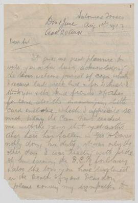
The file includes a letter, dated 19 August, describing a soldier's experience of a gas attack in Flanders and the effectiveness of the British artillery.